The oceans are responsible for absorbing a significant portion of carbon dioxide (CO2) emissions we release into the atmosphere, as well as 90% of the excess heat generated by climate change. The EU-funded ambitious project, GEORGE, which brings together 28 partners from academia and industry, and three environmental research infrastructures, EMSO ERIC, Euro-Argo ERIC, and ICOS ERIC, with the technical capacity to monitor different ocean essential variables, from the seafloor through the water column to the surface. GEORGE’s first objective is to develop innovative technologies for the ocean observation system, particularly for the in situ characterisation of the oceans CO2 uptake system and the measurement of CO2 fluxes on moving and fixed platforms. The overall objective is to enhance the capability of ERICs to generate wide-scale ocean carbon data of high spatial and temporal resolution. Let’s discover how and why the George project will benefit us in the knowledge, monitoring and health of the ocean.
FUTURE PERSPECTIVE IN OCEAN TECHNOLOGIES
Further development of new sensors and platforms for measuring CO2 in the ocean is urgently needed to understand ocean processes and monitor anthropogenic changes to ocean biogeochemistry. “The observing network of the future will very likely be a combination of different types of observations: traditional measurements from research ships, autonomous underwater vehicles, underway measurements from commercial ships and sailing boats, data measured on moorings, autonomous vehicles and floats. The new sensors and platforms being developed at GEORGE will largely improve data measured from moorings and autonomous vehicles. This will increase our ability to measure in-situ long time series and has the potential to increase our data coverage in remote regions”, explains Meike Becker, Scientist and Chair of the group of ICOS Ocean Stations, University of Bergen and Bjerknes Centre for Climate Research.
Not only: excitement is building among the RIs for future collaboration as there is a lot of potential for science and industry to come together. The project “will further develop the technical capabilities of each platform and RI, and very importantly allow these RIs to further collaborate, with best practices, data interoperability, common demo missions, calibration protocols, and uncertainties”, says Romain Cancouët, Operational Engineer, Euro-Argo ERIC Office, involved in several tasks of the project (WP3, WP5, WP6).
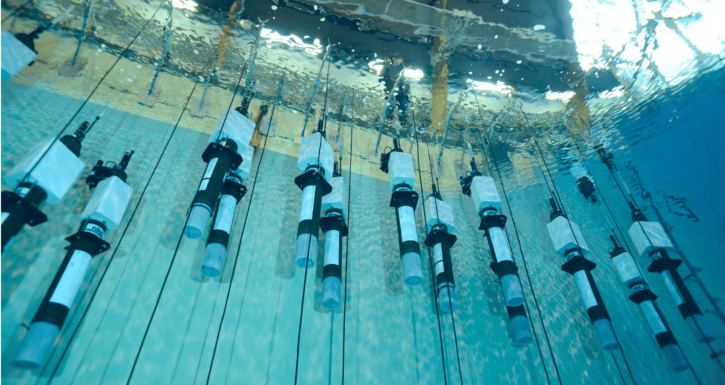
In the last decades, ocean observation has seen a huge advancement with the realization, deployment and use of several sensors or multi-platforms used over the world that allowed the scientific community to better understand the ocean dynamics and events that happen in the ocean: autonomous vehicles, fixed-point platforms, floats, buoys, Ship of opportunity and research vessels. Why is still useful to have different technologies for measuring the CO2 in the ocean observation system and what is the added value of having a multi-approach to the same ocean parameter (CO2) in this project?
“Different ocean monitoring technologies have their own advantages and disadvantages. For example, platforms such as Argo floats or small autonomous vehicles like ocean gliders are very light on logistics but they cannot carry large and power hungry sensors or take water samples for instance”, explains Simo Cusi, Engineering and Logistics Officer at EMSO ERIC, who will contribute to the advancement of technologies within the project. “Argo floats – Simo says – provide global coverage up to 2000m water depth in real-time, while ocean gliders can perform trajectories over thousands of kilometres down to 1000m water depth, being ideal for monitoring specific areas or oceanic structures. Unmanned surface vessels can carry larger sensors for longer periods, but only measure on the surface. Fixed-point platforms and buoys are suitable for long-term monitoring of specific areas, and research vessels are versatile for measuring many variables”.
Every platform has its unique benefits and requirements. “A research ship enables sampling for a wide range of extra parameters. Ships of opportunity offer continuous time series data with a high spatial coverage, with little space or power restrictions, but require autonomous instrumentation. Autonomous vehicles, floats and surface buoys offer measurements independent of research ship time or shipping lines, but with significant restrictions for sensor size, power consumption, maintenance or require the sensor to be submersible. The oceans occupy a vast area of the planet, however, CO2 observations are scarce and so far there is no ‘perfect’ platform on the horizon, that can satisfy all needs. As long as that is the case, we will continue to build the observation system using all the platforms we have available”, explains Meike.
Operating different technologies to measure the same variable helps “to reduce the single point of failure in case sensors are not working”, says Romain, who adds: “We need to keep our measuring capabilities at the best and latest standards in terms of sensors, platforms, data processing, quality control and expertise. And we need to go on working together since the different ocean observing networks are complementary”.
GEORGE BRINGS TOGETHER THE THREE MAIN EUROPEAN RESEARCH INFRASTRUCTURES
One of the main goals of the GEORGE project is the development of the next generation of sensors, systems and platforms which will increase our understanding of the state and dynamics of the ocean. The different ERICS together will create new synergies and will share standards and methods to measure, collect, process and distribute carbon cycle data, which is a very important step to making these data harmonized and useful to scientists worldwide (The role of the Marine Infrastructures in the European Marine Observation landscape: present and future perspectives Dañobeitia et al., 2023). Data will allow scientists to perform high-quality research to better understand the effects of carbon absorption by the ocean and will also be of great use to modellers to make predictions of the ocean and Earth’s climate.
HOW DO EACH RESEARCH INFRASTRUCTURE INVOLVED IN THE PROJECT WILL CONTRIBUTE TO THIS CHALLENGE?
ICOS stations observe greenhouse gas concentrations in the atmosphere as well as carbon fluxes between the atmosphere, the land surface and the oceans, providing standardised and open data from more than 170 measurement stations across 16 European countries. It aims to produce high-quality data to quantify the ocean carbon uptake and understand its driving mechanisms. “In ICOS we have 29 ocean stations that measure surface ocean pCO2, DIC, alkalinity, oxygen and nutrients from ships or surface moorings. To do so, we are using a wide range of autonomous instrumentation. In GEORGE, ICOS contributes the in-depth knowledge of CO2 monitoring. Many of our stations are used as platforms for field testing in GEORGE. Another important contribution is the experience and infrastructure around sensor calibration, CO2 data handling and quality control from both the OTC and the involved ICOS stations”, says Meike.
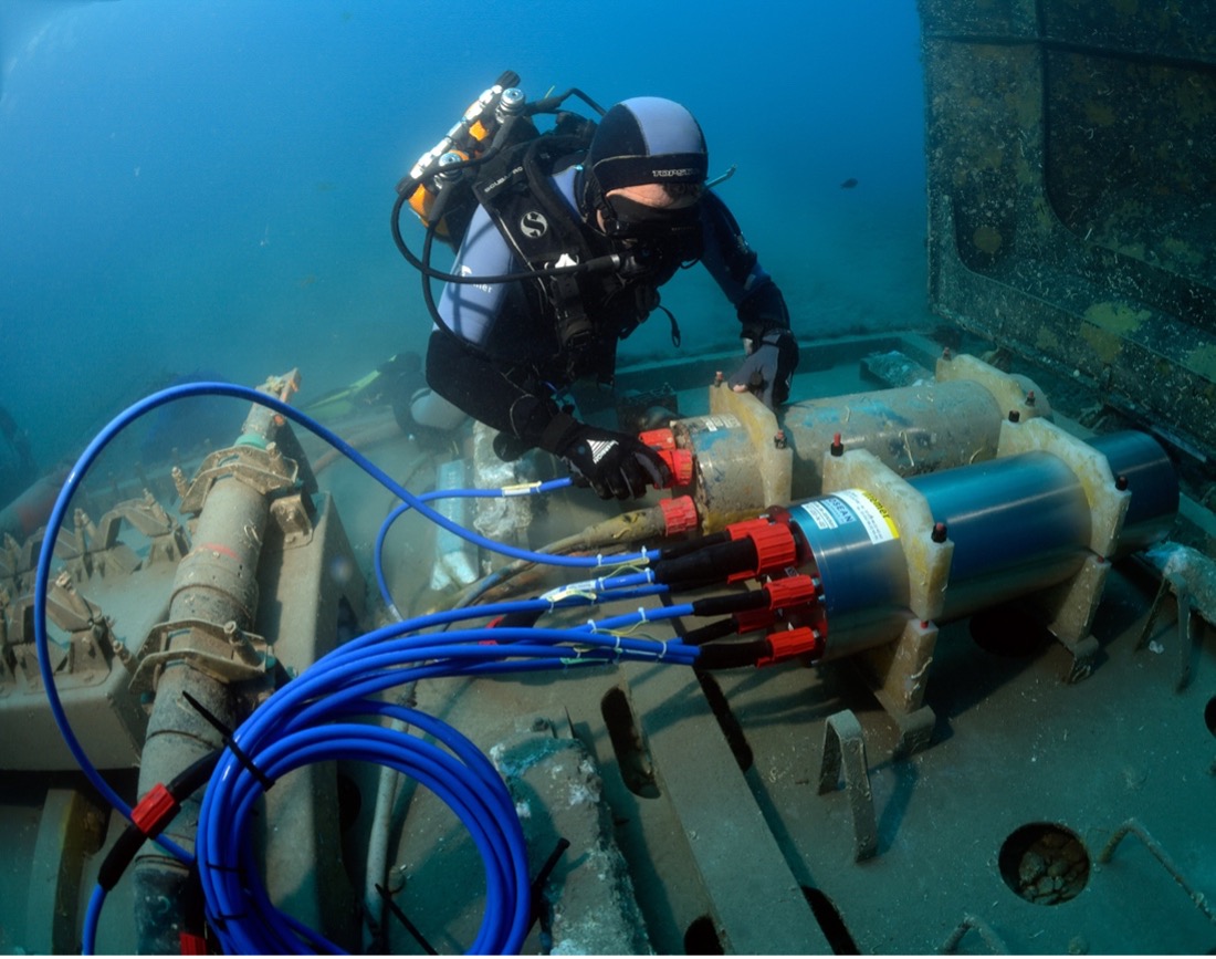
EMSO is dedicated to the observation of the European seas, from the surface to the seafloor and sub-seafloor, at specific locations, using fixed-point observatories. Observatories in this ERIC are multidisciplinary and measure a wide variety of parameters and differ substantially one from the other depending on the particularities of the site. Regarding the involvement of EMSO in the GEORGE project, Simo explains: “The development and ongoing implementation of the EGIM (EMSO Generic Instrument Module, N. Lantéri et al, 2022) within EMSO aims at standardizing the measurements across all observatories, adding to the existing particular measurements of each site a set of Essential Ocean Variables (EOVs) that will be distributed through the EMSO Data Portal. GEORGE will allow for a major upgrade of the EGIM: a lander system to deploy it on the seabed, a new rechargeable battery pack and the integration of state of the art sensors to measure most variables associated to the carbon cycle (pH, TA, DIC, pCO2 and CH4). Therefore, in the next years, EMSO, through the upgraded EGIM and the knowledge acquired by its members in the GEORGE project, will be able to shed some light on how the European seas absorb atmospheric carbon and how their chemistry evolves with time”.
The Euro-Argo aims to provide in situ ocean observations to a range of user communities, with an interest in the ocean’s state and its evolution. Regarding the involvement of this ERIC in the project Romain says: “For Argo floats specifically, there will be few/limited integration of new sensors in the GEORGE project. There will be the integration test of a passive acoustic sensor on a float, that indeed will enable to estimate wind speed for CO2 fluxes assessment. There will be the development and release of a ‘Linux core on BGC Argo floats’, which will enable easier R&D work on sensors and embedded processing. This will allow scientists to test new sensors onboard a float, by developing themselves the drivers, with a limited involvement of the float manufacturer”. And concludes: “Main other challenges are regarding the improvements of the Argo platforms themselves, and one activity within GEORGE will be to look at the feasibility to reduce data transmission bottlenecks. Another one will be the development and tests of Argo floats to work on shallow waters, which is a growing demand for European marginal seas, in complement to other ocean observing platforms”.
Photo: Dugornay Olivier (2017). EMSO-Ligure Nice – Addition of an electronic device on one of the underwater stations of the observatory. IFREMER. https://image.ifremer.fr/data/00623/73508/